Trail Walking Verneuil d'Avre et d'Iton - Francheville Iton Voie Romaine 16.4 Km - Photo

Francheville Iton Voie Romaine 16.4 Km

 ODDAD78
ODDAD78

User

© OpenStreetMap contributors
Length
Length
16.4 km
Max alt
Max alt
207 m
Uphill gradient
Uphill gradient
100 m
Km-Effort
Km-Effort  
17.8 km
Min alt
Min alt
176 m
Downhill gradient
Downhill gradient
102 m
Boucle
Boucle
Yes
Creation date :
2019-04-13 16:34:30.641
Updated on :
2019-04-13 16:34:30.672

(0 Reviews)

Walking
Walking
3h54
Difficulty : Easy

Scan this QR Code to open this trail in the SityTrail application

FREE GPS app for hiking

Logo SityTrail SityTrail

IGN / Geographical institutes

Download SityTrail from the App Store Download SityTrail from Google Play

Logo SityTrail SityTrail World

The world is yours!

Download SityTrail from the App Store Download SityTrail from Google Play Download SityTrail on Huawei AppGallery

About

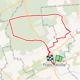
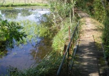
Trail Walking of 16.4 km to be discovered at Normandy, Eure, Verneuil d'Avre et d'Iton. This trail is proposed by ODDAD78.

Description

Offre touristique de l'Office de Tourisme Normandie Sud - Verneuil sur Avre

Elevation profile

Positioning

Country:
France
Region :
Normandy
Department/Province :
Eure
Municipality :
Verneuil d'Avre et d'Iton
Location:
Unknown
Start:(UTM)
342102 ; 5406097 (31U) N.

Trails nearby

Trail Walking Breteuil - Circuit des chemins des Isles -  Cintray - Photo
Walking
tracegps

Walking

Medium
(2)
Breteuil, Normandy, Eure, France
8.6 km | 9.1 km-effort
2h 10min
Yes
Trail Walking Breteuil - Cintray Chemin des Isles 8.2 Km - Photo
Walking
ODDAD78

Walking

Easy
(1)
Breteuil, Normandy, Eure, France
8.2 km | 8.7 km-effort
1h 56min
Yes
Trail Walking Verneuil d'Avre et d'Iton - Circuit de Malicorne - Francheville  - Photo
Walking
tracegps

Walking

Easy
Verneuil d'Avre et d'Iton, Normandy, Eure, France
4.4 km | 4.6 km-effort
1h 4min
Yes
Trail Walking Verneuil d'Avre et d'Iton - La Voie Romaine -  Francheville - Photo
Walking
tracegps

Walking

Difficult
Verneuil d'Avre et d'Iton, Normandy, Eure, France
16.1 km | 17.3 km-effort
4h 0min
Yes
Trail Walking Bourth - Circuit du Pré Saulé - Bourth - Photo
Walking
tracegps

Walking

Easy
Bourth, Normandy, Eure, France
5.5 km | 6.2 km-effort
1h 19min
Yes
Trail Walking Bourth - Bourth Circuit Pré Saul 5.5 Km - Photo
Walking
ODDAD78

Walking

Easy
Bourth, Normandy, Eure, France
5.5 km | 6.2 km-effort
1h 21min
Yes
Trail Walking Breteuil - Circuit des Passerelles - Cintray - Photo
Walking
tracegps

Walking

Easy
Breteuil, Normandy, Eure, France
2.8 km | 3.1 km-effort
45min
Yes
Trail Mountain bike Breteuil - Laguéroulde - Photo
Mountain bike
tracegps

Mountain bike

Difficult
Breteuil, Normandy, Eure, France
63 km | 69 km-effort
3h 30min
Yes
Trail Walking Breteuil - Le chemin des îles  - Photo
Walking
serleb

Walking

Easy
Breteuil, Normandy, Eure, France
10.8 km | 11.4 km-effort
2h 53min
Yes


Close
My subscriptions